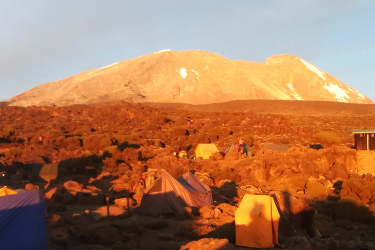
Machame Route 7 days
The Machame route is known as “Whisky route” compared to Marangu route “Cocacola” this is because Machame is difficult route and does not has sleeping hut for accommodation. Machame is the second most popular route on the mountain.
Price $2000
MACHAME ROUTE
Overview
Day 1 Machame Gate 1,800m (5,905 ft) to Machame Camp 2835m (9,301 ft)
Day 2 Machame Camp 2,835m (9,301 ft) to Shira Camp 3,850m (12,631 ft)
Day 3 Shira Camp 3,850m (12,631 ft) to Barranco Camp 3,900m (12,795 ft)
Day 4 Barranco Camp 3,900m (12,795 ft.) to Karanga Camp 3,950m (12,959 ft)
Day 5 Karanga Camp 3,950m (12,959 ft) to Barafu Camp 4,673m (15,331 ft)
Day 6 Barafu Camp 4,673m (15,331 ft.) to Summit 5,895m (19,340 ft) to Mweka
Day 7 Mweka Camp 3,100m (10,170 ft.) to Mweka Gate 1,800m (5,905 ft)
Day 8 Departure Day
Day 1 - Machame Gate 1,800m (5,905 ft) to Machame Camp 2,835 (9301 ft)
Elevation: Machame Gate 1,800m (5,905 ft) to Machame Camp 2,835(9301 ft)
Distance covered: 10.8km / 6.7mi
Time taken: 7 hours
At the gate you have to wait for registration and GCS’s team will be arranging your equipment for the whole hike. Once you leave the park gate you will walk through the rain forest on a winding trail up a ridge until you reach the Machame Camp.
Day 2 - Machame Camp 2835m (9,301 ft) to Shira Camp 3,850(12,631 ft)
Elevation: Machame Camp 2835m (9,301 ft) to Shira Camp 3,850 (12,631 ft)
Distance covered: 5.4km / 3.4mi
Time taken: 5 hours
Shortly after leaving the Machame camp you will leave the glades of the rain forest and continue on an ascending path to a steep rocky ridge, covered with heather. The route then turns west onto a river gorge onto the Shira Campsite.
Day 3 - Shira Camp 3,850m (12,631 ft) to Barranco Camp 3,900m (12,959 ft)
Elevation: Shira Camp 3,850m (12,600 ft) to Barranco Camp 3,900m (12,959 ft)
Distance covered: 10.8km / 6.7mi
time taken: 7 hours
From the Shira Plateau, you will continue to the east up a ridge eventually passing the Lava Tower, called the “Shark’s Tooth.” Shortly after the tower, you come to the second junction which brings you up to the Arrow Glacier and continuing on to the Barranco campsite.
Day 4 - Barranco Camp 3,900m (12,959 ft.) to Karanga Camp 3,950m (12,959 ft)
Elevation: Barranco Camp 3,900m (12,959 ft.) to Karanga Camp 3,950 (13,959 ft)
Distance covered: 5.5km / 3.4mi
Time taken: 4 hours
Leave Barranco after breakfast with a challenging scramble up the Barranco Wall. This is the most difficult part of the day. Once you reach the top of the wall you will make a small descent to the Karanga Valley and spend the night a Karanga Camp.
Day 5 - Karanga Camp 3,950m (12,959 ft) to Barafu Camp 4,673m (15,331 ft)
Elevation: Karanga Camp 3,950m (12,959 ft) to Barafu Camp 4,673m (15,331 ft)
Distance covered: 4km
Time taken: 3 - 4 hours
From Karanga head up a moraine ridge where views can be spectacular. The final stage to Barafu is quite steep, and as always it’s taken it very slowly. In the evening your guide briefs you for the final ascent.(See Machame Route 7 dayes for optional acclimatization Day: Stay a night at Karanga Camp (13,100 ft) before continuing the next day to Barafu Camp. This gives you a little extra time to acclimate.)
Day 6 - Barafu Camp 4,673m (15,331 ft.) to Summit 5895m (19,340 ft) to Mweka Hut 3,100m (10,170 ft)
Elevation: Barafu Camp 4,673m (5,331 ft.) to Summit 5,895m (19,340 ft) to Mweka Hut 3,100m (10,170 ft)
Distance covered: 16.4km / 9.6mi
Time taken: 12 - 15 hours
Very early in the morning (midnight to 2am), you will continue your way to the summit between the Rebmann and Ratzel glaciers. This is the most mentally and physically challenging portion of the trek. At Stella Point, you will stop for a short rest and will be rewarded with the most magnificent sunrise you are ever likely to see (weather permitting). It can be very cold at night at these elevations, but it will be quite warm by the end of the hiking day. You will want clothing for both extremes with you. From the summit, we now make our descent continuing straight down to the Mweka Hut camp site, stopping at Barafu for lunch. Mweka Camp is situated in the upper forest and mist or rain can be expected in the late afternoon.
Day 7 - Mweka Camp 3,100m (10,170 ft.) to Mweka Gate 1,800m (5,905 ft)
Elevation: Mweka Camp 3100m (10,170 ft.) to Mweka Gate 1,800m (5,905 ft)
Distance covered: 9.1km / 7.5miles
Time taken: 3 hours
From Mweka Camp you continue the descent down to the Mweka Gate. At lower elevations, it can be wet and muddy. Shorts and t-shirts will probably be plenty to wear (keep rain gear and warmer clothing handy). At the Mweka Gate summiting climbers receive their summit certificates. Our driver will meet you at the gate and transport you to your Arusha/Moshi hotel (depending on availability, overnight stay included in our packages.
Day 8 - Departure Day
Our packages include departure day services. Enjoy breakfast and a morning sightseeing in the city or join us for one of our Safari Adventures. If you are returning home our driver will bring you to Kilimanjaro International Airport (JRO) to catch your flight home.


